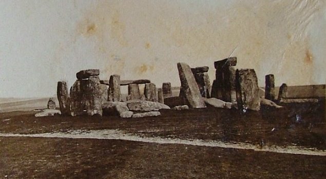
New discoveries have recently been made at the sight of the prehistoric monument Stonehenge in Wiltshire, England. Over the last five years, archeological research teams at Birmingham University have unearthed an ancient landscape beneath the Stonehenge complex.

With the use of high-tech radar equipment, researchers were able to survey 12 square kilometers of the surrounding area with such great precision, they have begun to map a blueprint of the timeline between constructed structures and monuments before and after the completion of Stonehenge.
–Last Thursday the first episode of Operation Stonehenge: What Lies Beneath aired on on BBC. If you didn’t get the chance to see the first episode, I’ve summarized it for you below:
1. First there were Three Pillars
Before the construction of Stonehenge there were three “totem-like” poles or pillars unconnected to the later site. During the Mesolithic Period, those people who inhabited the area built the success of society and civilization from hunter-gatherer strategies. Because of this, it is speculated that the first three pillars were constructed, when people migrated to the area around 10,000 years ago. Back then, the land was prime hunting territory with bovine aurochs (huge wild cattle), and an abundance of flint also ensured the warmth of a fire.
 2. Then–Britain became an Island

About 8,200 years ago, the land that connected the Isle of Britain from the mainland continental Europe began to flood. The totality of what was Doggerland fell back into the sea by about 6,000 BCE, and the inhabitants of the Stonehenge area became isolated and stopped producing monuments for a few centuries to follow. Thus, a period of standstill began after the flood and around the construction of Robin Hood’s Ball (a causeway enclosure).
3. Robin Hood’s Ball Marks the Birth of the Neolithic
As people began to retire from hunter-gatherer survival techniques and settle the area surrounding Stonehenge, the continuous construction of causewayed enclosures similar to Robin Hood’s Bowl can be seen repeated across the isle. Circular ditches and gaps or the causeways distinguish this feature, and its existence suggests the separation of land as territory or rising local tension between groups in the area.
4. A Community Grave for Early Rituals Stood Before Stonehenge
An intricate ‘Long Barrow’ grave design as seen throughout continental Europe shows the rising Neolithic influences into the area. The Long Barrow grave can be found 2 kilometers east of Stonehenge and stands a far more advanced structure than all previous known architecture at the site. This particular community burial tomb was the place of ritual ceremonies and rites of the dead. These mass graves were speculated to house up to 50 people before being sealed.
5. The Greater Cursus Topped All Previous Architecture
A long oval-shaped causeway structure built similar to Robin Hood’s Ball spans across 2.5 kilometers near the site of Stonehenge.

Such an extensive enclosure of ditches and causeways was not made possible without the use of Neolithic Era technology and tools such as flint axes. This particular Cursus is suggested to have been connected with an early processional route. At either end of the Greater Cursus, two pits were found. These pits mark the location of a solar alignment and demonstrate the rising importance of the calendar to the Neolithic farmer.
6. The Local People Mined Flint on an Industrial Scale
Flint mines can be found nearby the surrounding area of Stonehenge with Neolithic industrial projects such as Grimes Graves. It is suggested the flint coloured with rare pink algae (Hildenbrandia rivularis) near Stonehenge became a mythical icon of the land, and if held under the warm water springs in the area, a normal flint would be turned bright pink. After Neolithic technologies reached the island, flint mines appeared in the form of circular ditches carved 12.5 meters into the ground and connecting in patterns beneath the earth.

7. The Pits of the Cursus Align with the Summer Solstice
Two pits were discovered at either side of the Greater Cursus to mark the presence of a solar alignment on Midsummer’s Day or the date of the summer solstice. At sunrise on the summer solstice, the sun ascending above the eastern horizon aligned with the eastern pit, and at sunset, the sun descending below the western horizon aligned with the western pit of the Cursus along with the exact location where Stonehenge would be completed centuries later. With the rise of agrarian society in the Neolithic Era, time-tracking and seasonal marking monuments became more common. The grand size of the Greater Cursus suggests a ceremony that lasted an entire day.
8. Successful Surgeries were Accomplished by Neolithic Physicians
After excavating the area surrounding Stonehenge, skulls were unearthed that display what researchers speculate to be an early form of surgery. Despite the lack of modern medical knowledge, skulls showing signs of weapon injury were uncovered to demonstrate how early physicians were still able to heal their patients in a process known as ‘trepanning’. Signs of healing around the operated area confirm that some people were able to not only survive the battle but live to tell the tale.
–The next episode of Operation Stonehenge: What Lies Beneath is set to air on Thursday September 18th at 8:00 pm. Stop by the Oracle’s Library for an overview of episode two next week.
